For many organizations, a drone deliverable starts with imagery. That makes sense. Aerial photos and video are fast, persuasive, and easy to use in marketing, reporting, and documentation. But some projects demand more than visuals. They require measurement, elevation intelligence, terrain modeling, and data that can support engineering, planning, asset management, and operational decision-making.
That is where LiDAR drone services become valuable.
LiDAR—short for Light Detection and Ranging—is a remote sensing method that uses laser pulses to measure distance and generate precise three-dimensional information about land and surface features. The raw collection is typically a point cloud, which can then be processed into deliverables such as digital terrain models, digital elevation models, contours, and other mapping products.
In a market like St. Louis, where businesses and institutions manage everything from construction sites and industrial properties to transportation corridors, utility assets, rooftops, campuses, and large commercial parcels, LiDAR can be the difference between “good enough for viewing” and “reliable enough for planning.”
What makes LiDAR different from standard drone imaging?
Traditional drone photography and photogrammetry are excellent tools, especially when the goal is marketing content, progress photography, visual inspection, or 3D modeling based on overlapping imagery. LiDAR serves a different purpose. Instead of relying only on photographs, it actively measures the environment with laser pulses, which makes it especially useful when you need elevation-based data and dense spatial information rather than just appearance. NOAA and USGS both describe LiDAR as a method for collecting accurate 3D information and point-cloud data that can be processed into bare-earth elevation products.

This distinction matters for decision makers. A marketing director may want dramatic aerial views. A facilities team may want measurable roof geometry. A civil engineer may need terrain models. A developer may need better site intelligence before design, grading, drainage, or access planning moves forward. A quarry or industrial operator may want volumetric understanding rather than just visual documentation.
In other words, photogrammetry shows you a site. LiDAR helps quantify it.
Why organizations hire LiDAR drone services
The strongest reason to commission LiDAR is not novelty. It is efficiency.
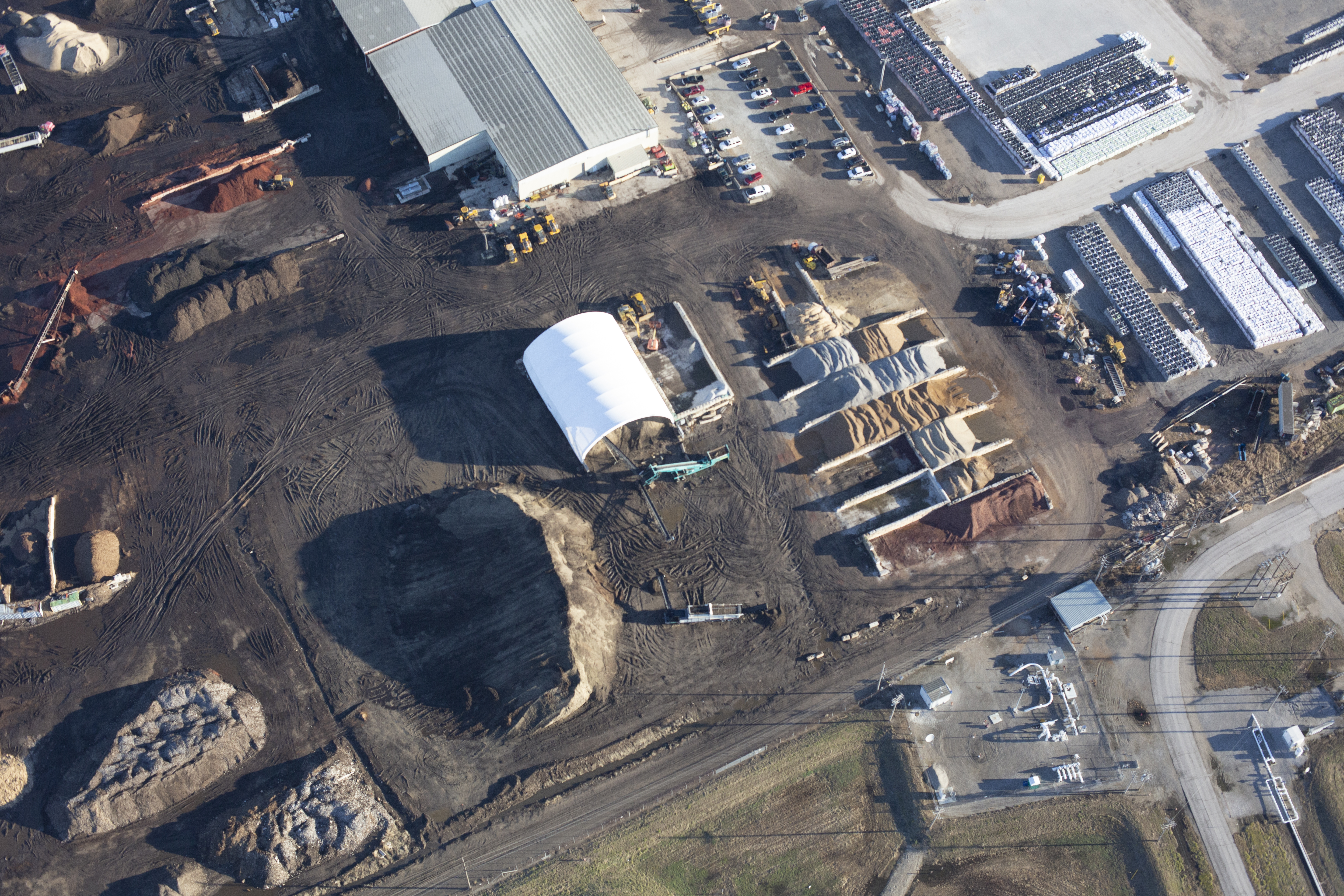
When a site is large, difficult to access, hazardous, uneven, vegetated, or operationally sensitive, collecting data from the air can reduce field time while improving coverage. The value is often not just in flying the mission, but in giving stakeholders a dataset they can reuse across departments and project phases.
Common use cases include:
- topographic mapping
- terrain and surface modeling
- pre-construction site evaluation
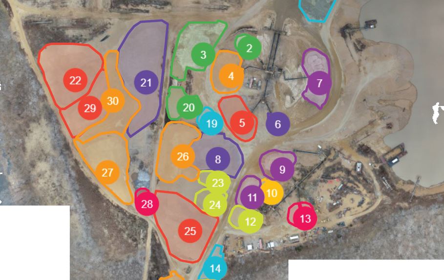
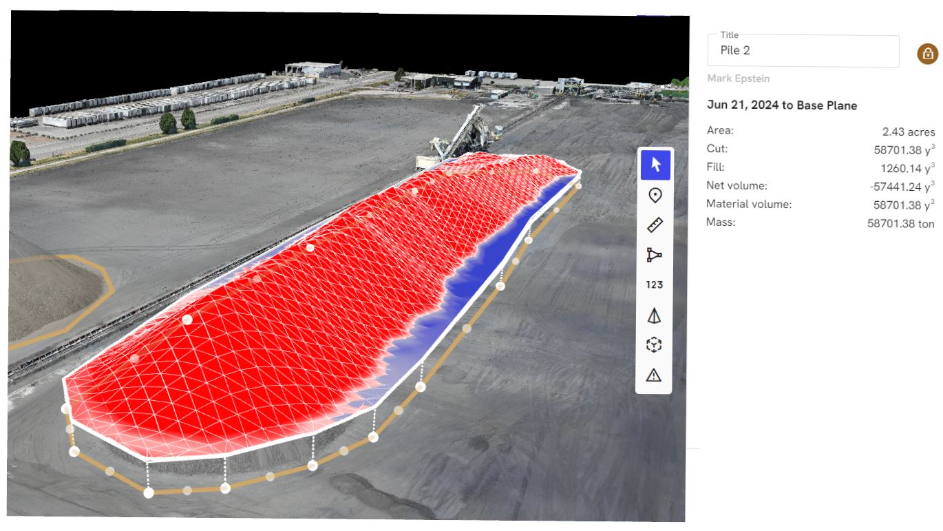
- stockpile and volumetric analysis
- corridor and infrastructure documentation
- roof and facility measurement
- stormwater and drainage review
- land development planning
- utility and industrial site documentation
- large-campus and institutional asset mapping
For some of these projects, standard imagery may still be enough. For others, LiDAR becomes the better tool because the question is no longer “What does this look like?” but “What exactly is here, how does it vary in elevation, and how can we model it?”
LiDAR is especially useful when vegetation or surface complexity becomes a problem
One of the most important distinctions between LiDAR and simple imagery workflows is how the resulting data can be classified and processed. USGS notes that LiDAR data are initially captured as point clouds containing returns from structures, vegetation, and ground, and that bare-earth elevation products are produced by removing non-ground features. That makes LiDAR particularly valuable when the underlying terrain matters more than the visual clutter on top of it.
That has real implications in commercial and industrial environments. If your project involves embankments, detention areas, uneven ground, drainage paths, wooded edges, utility corridors, or a property with inconsistent grade, LiDAR can help reveal the surface in a way standard photography often cannot on its own.
For organizations making capital, engineering, maintenance, or land-use decisions, that can translate into fewer assumptions and better planning.


What decision makers should expect from a professional LiDAR workflow
LiDAR is not just about putting a sensor in the air. The quality of the result depends on planning, control, flight execution, processing, classification, accuracy strategy, and deliverable design.
A serious LiDAR workflow should begin with the business question. Are you trying to support engineering? Estimate material volume? Understand drainage? Document site conditions before construction? Create an archive for future design comparison? Build a long-term facilities dataset? The right workflow depends on the answer.
From there, a professional team typically evaluates:
- site size and access
- airspace and safety requirements
- vegetation and obstruction density
- target accuracy and project tolerances
- need for ground control or checkpoints
- coordinate system and datum requirements
- output format requirements for downstream software
- whether imagery should be captured alongside LiDAR
Accuracy is not a casual topic in mapping. ASPRS maintains positional accuracy standards for digital geospatial data specifically because mapping deliverables need to be tied to defined accuracy expectations and best practices rather than assumptions.
That is why experienced providers do more than collect data. They define the deliverable, the intended use, and the level of confidence the project requires.
Deliverables matter as much as the flight
Many buyers focus on the drone and sensor. Experienced clients focus on the output.
LiDAR projects can produce a range of deliverables, including classified point clouds, terrain models, elevation surfaces, contour files, orthographic context imagery, section cuts, measurement-based visuals, and integration-ready files for CAD, GIS, engineering, or facilities platforms. USGS references common products such as point clouds and bare-earth digital elevation models as foundational outputs from LiDAR collection.
That means the real question is not, “Can you fly LiDAR?” It is, “Can you deliver data our team can actually use?”


For marketing and communications teams, that may mean clear visuals that translate technical data into understandable presentations for internal stakeholders, investors, boards, or clients. For engineers and project managers, it may mean receiving mapping products in the right format, coordinate system, and structure for immediate use.
The best LiDAR providers understand both audiences.
LiDAR is not a replacement for commercial photography and video
This is where many conversations go wrong. Organizations sometimes assume LiDAR replaces imagery. It does not. It complements it.
A smart production strategy often combines technical capture with visual storytelling. You may need LiDAR for terrain intelligence, aerial photography for reports, ground photography for asset condition, and video for internal communications, investor relations, proposals, recruiting, or public outreach.
That combination is often where the greatest value appears. A single field deployment can support engineering, operations, marketing, training, and executive communication at the same time.
For businesses and organizations in St. Louis, that matters. Budgets are tighter when departments operate in silos. They go farther when one production strategy creates multiple usable assets.
Compliance, safety, and operational discipline are not optional
Commercial drone operations in the United States fall under FAA requirements for certificated remote pilots and Part 107 operating rules for small unmanned aircraft. The FAA’s commercial operator guidance notes that certificated remote pilots may conduct commercial small-UAS operations subject to those rules and any applicable airspace requirements.
For clients, the takeaway is straightforward: the right drone partner should already be thinking about safety, airspace, site restrictions, crew roles, and mission planning before the aircraft is ever launched.
That is particularly important in active commercial settings where flights may occur around buildings, parking lots, industrial yards, campuses, rooftops, or operational facilities. Technical capability matters, but operational judgment matters just as much.
Questions smart clients ask before hiring LiDAR drone services
Experienced buyers usually ask better questions than “What drone do you use?”
Better questions include:
- What problem are we solving with LiDAR?
- What level of accuracy is realistic for this site and deliverable?
- What files will we receive?
- Can the outputs work with our internal software or consultant workflow?
- Will we also receive visual assets for presentations or communications?
- How will the site be planned for safety and compliance?
- What parts of the process are handled in-house versus outsourced?
- Can the same production team also support photography, video, interviews, and branded content?
That last question is often overlooked. If your organization already needs visual media, site documentation, executive interviews, training footage, or marketing assets, there is a major advantage in working with a team that understands both technical capture and polished media production.
The strategic case for LiDAR in St. Louis
In practice, LiDAR drone services make the most sense when the cost of uncertainty is higher than the cost of capture.
If a site condition is difficult to interpret, if access is inefficient, if the terrain needs to be modeled, or if the property will be revisited repeatedly over time, LiDAR can provide a stronger informational foundation than standard imagery alone.
It is also useful when internal stakeholders need a common reference point. Operations, facilities, engineering, marketing, leadership, and outside consultants often evaluate the same property from different perspectives. A well-executed LiDAR project can create a shared dataset that supports all of them.
That makes LiDAR more than a drone service. It becomes a decision-support tool.

Why experience matters
LiDAR projects are rarely just about the flight. They are about understanding the client’s objective, choosing the right capture method, managing the site professionally, and delivering outputs that are technically useful and visually understandable.
That requires more than a pilot. It requires a production-minded team that understands location work, technical imaging, data handling, file delivery, client communication, and how to convert specialized capture into practical business value.
At St Louis Commercial Photographers, we bring that broader perspective to every assignment. We are a full-service professional commercial photography and video production company with the right equipment and creative crew service experience for successful image acquisition. We offer full-service studio and location video and photography, as well as editing, post-production and licensed drone services. St Louis Commercial Photographers can customize your productions for diverse types of media requirements. Repurposing your photography and video branding to gain more traction is another specialty.
We are well-versed in all file types and styles of media and accompanying software. We use the latest in Artificial Intelligence for all our media services. Our private studio lighting and visual setup is perfect for small productions and interview scenes, and our studio is large enough to incorporate props to round out your set. We support every aspect of your production—from setting up a private, custom interview studio to supplying professional sound and camera operators, as well as providing the right equipment—ensuring your next video production is seamless and successful. We can fly our specialized drones indoors.
As a full-service video and photography production corporation, since 1982, St Louis Commercial Photographers has worked with many businesses, marketing firms, and creative agencies in the St. Louis area for their marketing photography and video. When your project calls for both technical aerial capability and polished visual production, we bring the experience, equipment, and creative judgment to help you capture the right data and turn it into useful deliverables.
